Solano Canyon
  • Home
  • About
  • History
    • Timeline
    • Street Name Histories >
      • Solano Avenue
      • Buena Vista Road
    • People of Solano >
      • Francisco Solano
      • Rosa Casanova
      • Alfredo Solano
      • María Solano
      • Guillermo Bouett
    • Photos
  • Blog
  • 1866 Org.
  • City Service Requests

Cruise through time up Buena Vista Street

9/26/2015

Comments

 
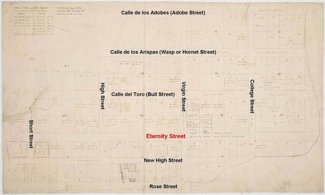
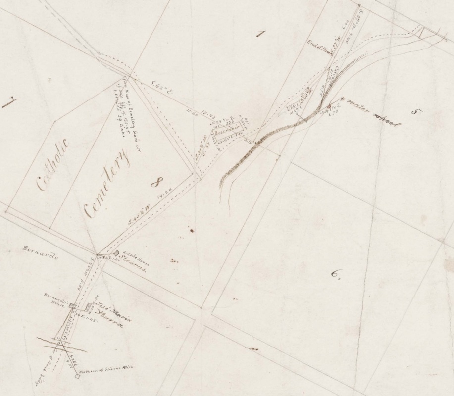
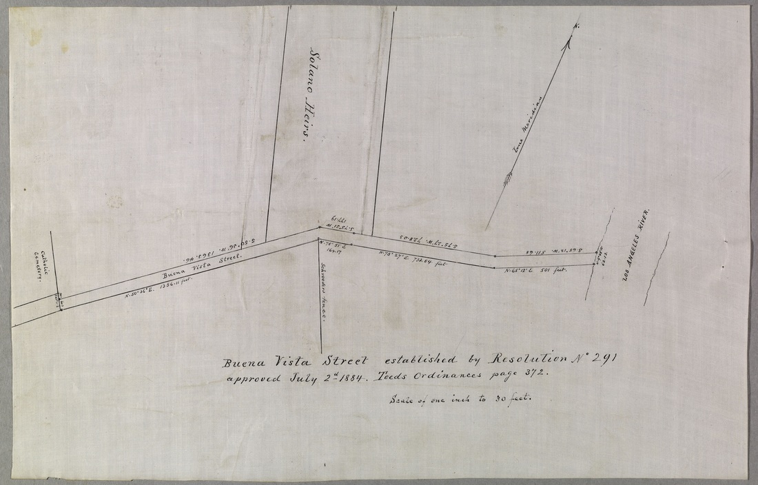
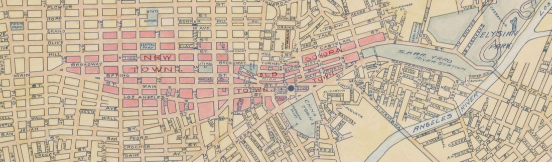
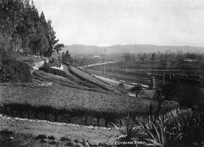
This blog traces the genealogy of Buena Vista Street, which we all know today as North Broadway.  But it was not always so;  Buena Vista Street has undergone several name changes over time, although its alignment has remained relatively constant.

Follow along as we trace the history of this, well, 'historic' Los Angeles street, from Downtown to the Los Angeles River and beyond ...

The pathway to Eternity

Eternity Street
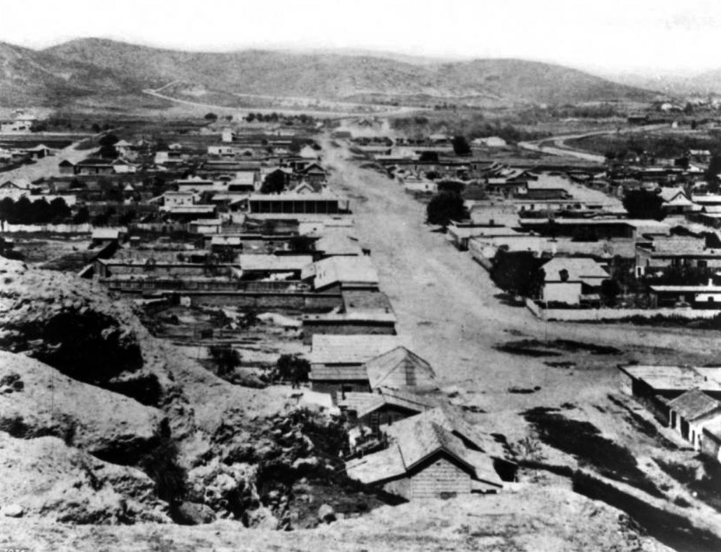
The View up Eternity Street from Fort Hill, ca. 1879 [CHS-7078]
No, this isn't a secret recipe for how to get to Heaven.  Each of us has his or her own ideas about how that works.

One of the first things that was required of the newly-formed pueblo that was Los Angeles in 1781 was to figure out how to dispose of those who died.  We do not know the exact location of the first church, nor that of the Plaza, for that matter; but it is reasonable to assume that the first burials took place in a cemetery at, or near, the church itself.

Eventually — and like the location of the first cemetery, the exact date is uncertain — the Catholic Church acquired some land a short distance to the northeast of the pueblo, at the mouth of a ravine against the base of the Stone Quarry Hills.  The ravine was the second one to the East that came down from the hills and it became known as Cemetery Ravine, for obvious reasons.  The exact location and size of the cemetery is well-documented, however, as shown on several early maps of the area, including this one from 1857.
Calvary Cemetery, 1857
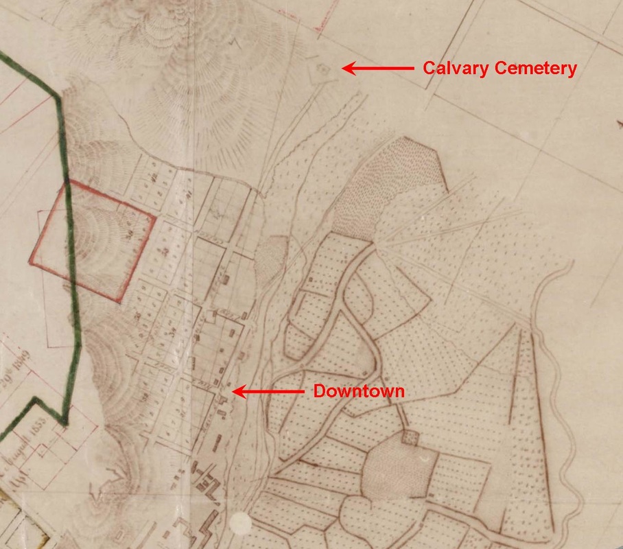
Location of Calvary Cemetery, 1857 [SR Map 0335]
The street that led from Downtown to Calvary Cemetery was called Calle Eternidad, which was later Anglicized to Eternity Street  Like all streets in Los Angeles, it was a dusty, unpaved street that, by the time it reached Calvary Cemetery, was little more than a trail for horses, burros, and wagons.


Here comes Fort Street

Beginning at the south side of Fort Moore Hill and running to First Street was a street that is shown on Lt. E.O.C. Ord's original 1849 map of Los Angeles named Fort Street.  Ord's map was later incorporated into other maps, including this one made in 1853 and this one made in 1857 by George Hansen.
Ord's Map
Downtown Streets from 1849, 1853, and 1857 [SR Map 0336]
It's nearly impossible to read the street names on this old map, so here is the same map with the street names annotated.
Annotated Streets
Downtown Streets from 1849, 1853, and 1857, annotated
Fort Street is not shown on these maps.  It is roughly parallel to Eternity Street, and to the left of Short Street.  In 1890, Fort Street, from 10th Street up to 1st Street, was renamed Broadway.  From 1st Street up to California Street, it became North Broadway.

Meanwhile, people who wanted to get to the north of Los Angeles, or to east of the river, followed a simple trail that began at the end of Eternity Street, at Calvary Cemetery.  The dotted line on this map from 1868 shows the trail that existed from Calvary Cemetery to the river. Also of interest on this map are the locations of la Zanja madre and the water wheel.
Picture
Map showing the trail from Calvary Cemetery to the river [SR Map 0375]


Bueva Vista Street becomes a reality


Then, in 1884, Eternity Street was renamed Buena Vista Street and was established all the way to the Los Angeles River.   The parcel labeled "Solano Heirs" is the original, 17-acre parcel that became the first 100 lots of the Solano Canyon community.
Picture


Broadway and Buena Vista Street are connected


But there was no easy way to get from North Broadway onto Buena Vista Street without going around Fort Moore Hill, so a tunnel was bored beneath Fort Moore Hill, which allowed North Broadway to connect directly with Buena Vista Street.  The tunnel was opened to traffic in 1901 ...
Broadway Tunnel
The Broadway Tunnel, which opened to traffic in 1901. It was 65 feet from the street to the top of Fort Moore Hill.

 
After much hand-wringing, Buena Vista Street became North Broadway in 1909


There were several proposals to the City Council over time to change the name of Buena Vista Street to North Broadway.  These proposals were usually met with a chorus of objection by those who lived along the street and who bemoaned the loss of the original, Spanish names of many of Los Angeles' Streets.  Calle Principal became Main Street; Calle Primavera became Spring Street; Calle del Toro became Bull Street; Calle de las Arispas became Wasp Street; and on an on and on ...  And Calle Eternidad became Eternity Street.

And even though Calle Eternidad became Buena Vista Street — a hybrid between the Spanish Buena Vista and the English 'Street' — eventually, in 1909, Buena Vista Street did, indeed, become North Broadway.


This 1897 map helps to understand the streets


This 1897 map by Sidney Reeve, surveying partner of Alfred Solano, helps to make clear the location of some of the early Los Angeles streets.
Reeve's 1897 map
Portion of an 1897 map showing the streets of Los Angeles [SR Map 0744]

Begin at the left-hand edge of this strip of map.  Locate Main Street, near the center of the left-hand edge of the map.  About four blocks in, Main Street splits into Main Street and Broadway.  After another two blocks, Main Street splits again, into Main Street and Spring Street.

Now go back to the Main Street-Broadway split.  Follow Broadway about ten blocks to the right to the Broadway Tunnel.  Upon exiting the tunnel, one is on Buena Vista Street.  Buena Vista Street may then be followed all the way to the Los Angeles River.

After the name change of 1909, this entire route became Broadway and North Broadway, which was eventually extended across the river all the way to Avenue 18, the portion east of the river replacing Downey Avenue.

This extension east of the river was made possible by construction of the Broadway Bridge over the Los Angeles River, which was opened to traffic in 1911.  Elysian Park may be seen in the photograph on the heights beyond the bridge.  This view is from the South, looking North.
LOC Broadway Bridge
Broadway Bridge across the Los Angeles River [Library of Congress]

At one time, Buena Vista Street, now North Broadway, provided a beautiful access point to Elysian Park.
Elysian Park entrance
Buena Vista Street entrance to Elysian Park, ca. 1920s
Comments

    About the Author

    Lawrence Bouett is a retired research scientist and registered professional engineer who now conducts historical and genealogical research full-time.  A ninth-generation Californian, his primary historical research interests are Los Angeles in general and the Stone Quarry Hills in particular.  His ancestors arrived in California with Portolá in 1769 and came to Los Angeles from Mission San Gabriel with the pobladores on September 4, 1781.

    Lawrence Bouett
    Lawrence Bouett may be contacted directly here.

    Archives

    July 2018
    June 2018
    May 2018
    April 2018
    October 2016
    September 2015
    August 2015
    July 2015
    June 2015
    May 2015
    April 2015
    March 2015

    Categories

    All

    RSS Feed

Powered by Create your own unique website with customizable templates.
  • Home
  • About
  • History
    • Timeline
    • Street Name Histories >
      • Solano Avenue
      • Buena Vista Road
    • People of Solano >
      • Francisco Solano
      • Rosa Casanova
      • Alfredo Solano
      • María Solano
      • Guillermo Bouett
    • Photos
  • Blog
  • 1866 Org.
  • City Service Requests