The truth about who owned the land in Chavez RavineFor some reason, there seems always to have existed confusion about who owned the land on which the three so-called Chavez Ravine communities — la Loma, Palo Verde and Bishop — came to be. The answer is simple: With the exception of a small portion of Palo Verde, and all of Bishop, the land originally belonged to Francisco Solano and his heirs. The following map is quite busy, but, hopefully, an explanation will clarify the map. 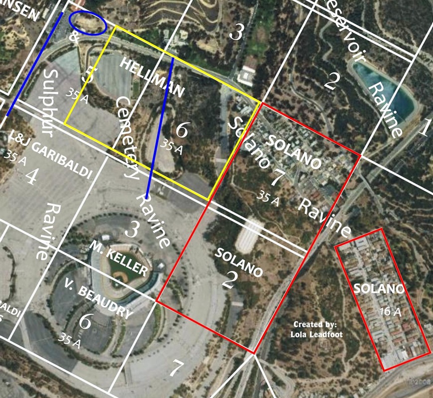 Map credit: Lola Leadfoot The red rectangle at the lower-right of the map is the original 16-acre Solano Tract that, today, is the lower Solano Canyon community. The large red rectangle is the remaining 70 acres originally purchased by Francisco Solano in 1866 (along with the 16 acre parcel, for a total of 86 acres).
The yellow rectangle is an additional 52½ acres that were purchased by George Hansen and subsequently sold to the heirs of Francisco Solano, making a total of 138½ acres that were owned by Francisco Solano's heirs. The upper portion of Lot 7 (in the red rectangle), plus a small piece of Lot 6 (the upper portion of the yellow rectangle) is Solano Tract No. 2, which is, today, the upper part of Solano Canyon. Where, then were la Loma and Palo Verde? Look at Lots 6 (in yellow) and 7 and 2 (in red): the loma — for which the community of la Loma took its name — can clearly be seen. The blue line in Lot 6 is the remnant of Bishop's Road, and it marked the boundary between la Loma and Palo Verde. The upper blue line is the remnant of Boylston Street. Palo Verde, then, was all of that remaining portion of Lot 6, plus all of Lot 5, between Bishop's Road and Boylston Street. For reference, the blue oval is the LA Police Academy. Bishop was located below Palo Verde, roughly in the upper half of Lot 4 that is labeled "L & J Garibaldi"; in fact, there was a Garibaldi Street in the Bishop community. The double white line between Palo Verde and Bishop was Effie Street. Note that missing altogether is any reference to Julián Cháves. Cháves never owned any of the land that made up any of the so-called Chavez Ravine communities; in fact, the Chavez Ravine communities had nothing at all to do with Chavez Ravine itself; rather, they were located in Sulphur, Cemetery, and Solano Ravines. How the myth of Julián Cháves was inserted into the communities that bore his family name remains a mystery; but, in any case, it is categorically untrue. |
About the AuthorLawrence Bouett is a retired research scientist and registered professional engineer who now conducts historical and genealogical research full-time. A ninth-generation Californian, his primary historical research interests are Los Angeles in general and the Stone Quarry Hills in particular. His ancestors arrived in California with Portolá in 1769 and came to Los Angeles from Mission San Gabriel with the pobladores on September 4, 1781. 
Lawrence Bouett may be contacted directly here.
Archives
July 2018
Categories |
 RSS Feed
