Solano Canyon
  • Home
  • About
  • History
    • Timeline
    • Street Name Histories >
      • Solano Avenue
      • Buena Vista Road
    • People of Solano >
      • Francisco Solano
      • Rosa Casanova
      • Alfredo Solano
      • María Solano
      • Guillermo Bouett
    • Photos
  • Blog
  • 1866 Org.
  • City Service Requests
  • Mission San Conrado

The Original Solano Avenue Elementary School

6/21/2015

Comments

 
Los Angeles, California, 1900.  The Twelfth United States Census, taken on June 1, 1900, revealed that there were 104,703 people living in the City of Los Angeles, with an additional 70,000 or so living outside the City in the county.  Of the nearly 105,000 residents of the City, slightly more than 32,000 of them were children under the age of 18 --in other words, children of school age.

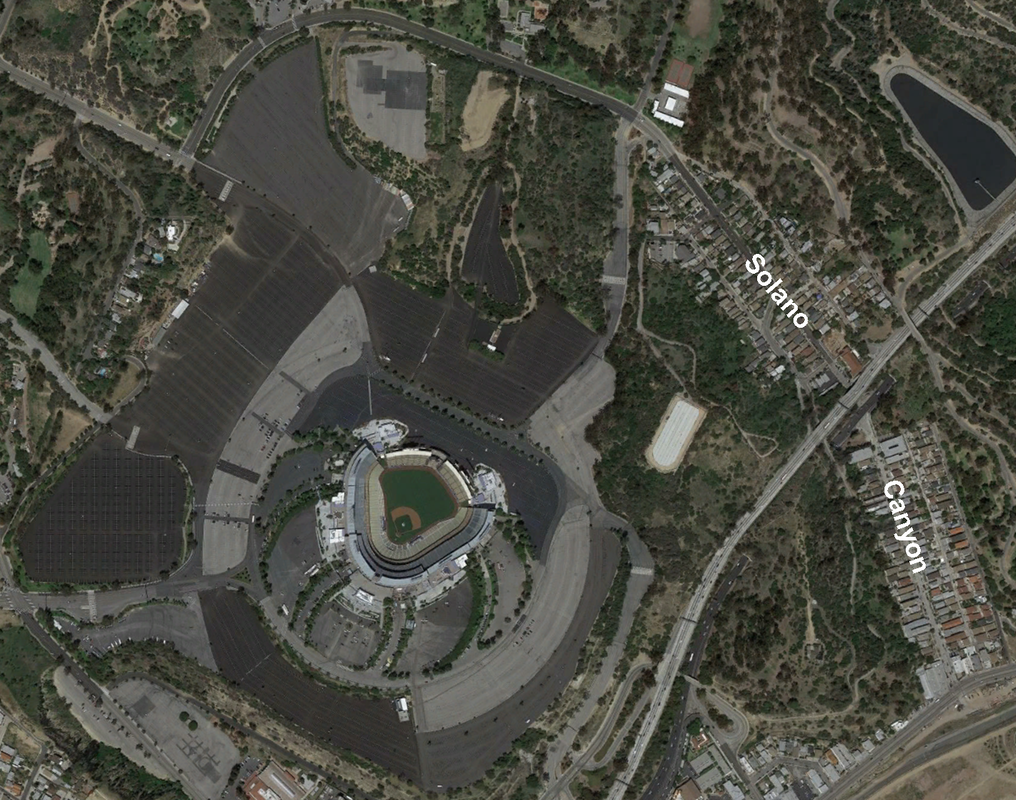
The Solano Canyon community grows

By 1900, Solano Canyon was home to 52 families:  8  lived on Buena Vista Road (now North Broadway), 10 lived on Casanova Street, and 34 lived on Solano Avenue, for a total of 196 people.  As many as 80 of these were children, many of whom were of school age.  The first home in the la Loma community was not built until 1909, a 12' x 12', one-room house at 814 Spruce Street built by John Radulovich.

A school bond election passes

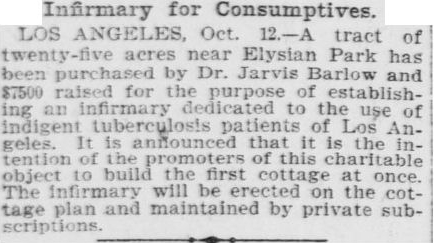
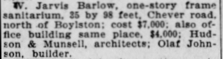
By 1903, Los Angeles City schools were being described as "... fearfully crowded ...".  Early that year, a bond election was held in Los Angeles, the purpose of which was to sell bonds to pay for construction of new schools within the City.  The bond issue passed easily, and as a result of the election, at its meeting of April 21, 1903, the Building Committee of the City Council met and awarded contracts for the architectural design and construction of 18 new elementary schools, a Polytechnic High School, and a warehouse.  It was the largest amount of money ever awarded for construction of schools in Los Angeles' history:  $476,625, slightly less than half of which ($200,000) was allocated for the new Polytechnic High School alone.  The new Solano Avenue School was one of the smaller schools in the group, at four rooms plus some site work, and the value of the contract was $12,500.  The architectural contract was let to the firm of Hudson & Mansell, a Los Angeles architectural firm that a year earlier had donated its services to draw up the plans for the new Barlow Sanatorium on Chavez Ravine Road.

Solano Canyon gets its own school

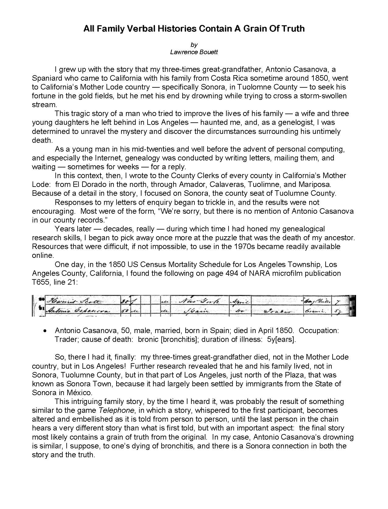
It is not known with certainty when the new Solano Avenue elementary school first opened its doors to students, but it must have been during the 1903-1904 school year or possibly the year after that, because the Board of Education, at its regular meeting held January 25, 1904, assigned Miss Addie J. Samuels, then a teacher at the Swain Street School, as teacher at the new Solano Avenue School and named her principal as well.
Addie J. Samuels was a long-time teacher and principal in Los Angeles.  She was an active teacher from at least 1885, and she came to Los Angeles for the 1892-93 school year as a 3rd- and 4th-grade teacher at the Swain Street School, located on the corner of N. Griffith Avenue, where she remained until her assignment to the Solano Avenue School in 1903.  In 1906-07, she was named principal at the Breed Street School, where she remained at least through the 1910-11 school year, and as late as 1918, she was the principal of the Sixty-eighth Street School at 714 Iola St., in a career that spanned more than 33 years.
At a special session of the Board of Education held August 22, 1904, it was announced that the 1904-05 school year would begin on Monday, September 25, 1904.  Miss Mary L. Small, a teacher in Los Angeles since 1893, and Miss Clara E. Heald were assigned as teachers at Solano elementary, with Addie J. Samuels remaining as principal.
Solano Avenue schools 1923
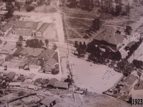
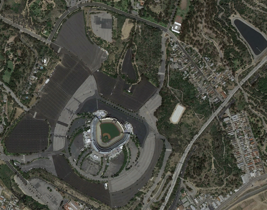
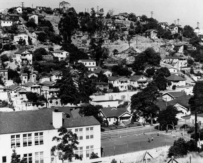
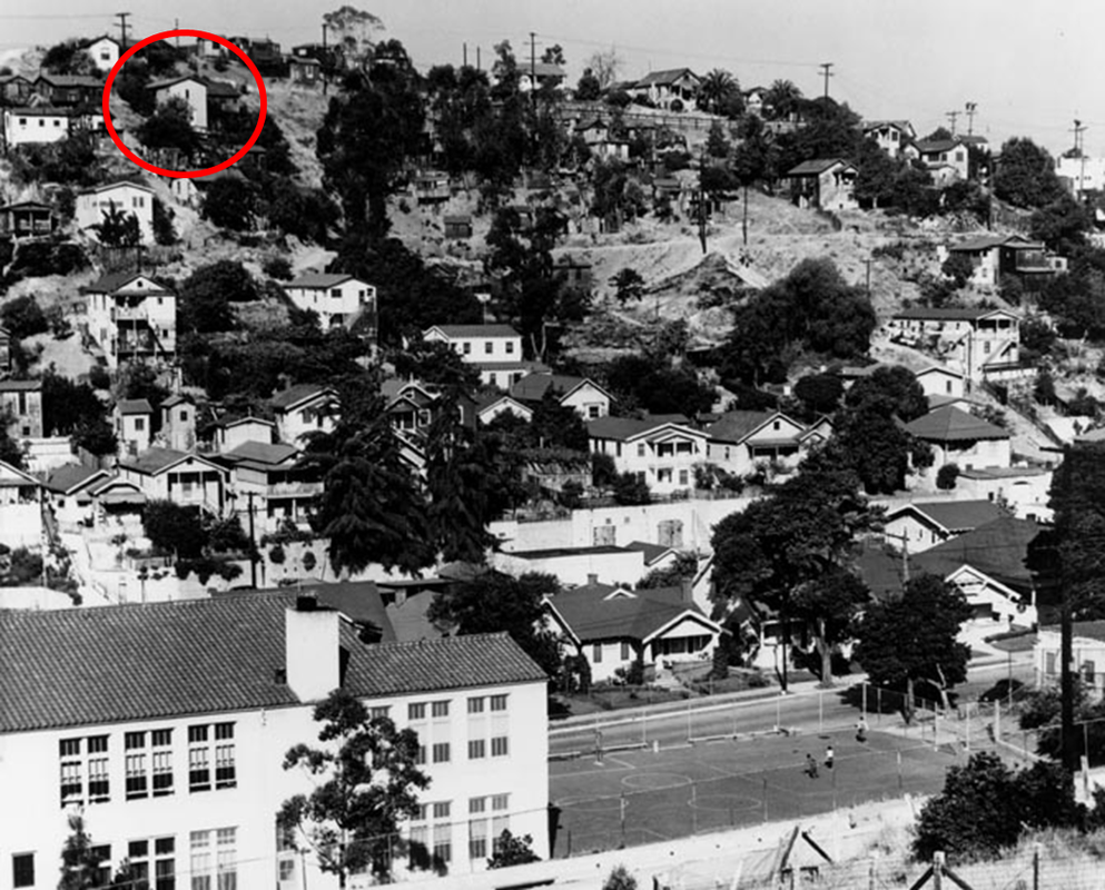
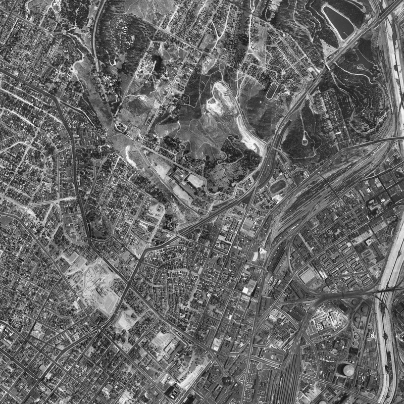
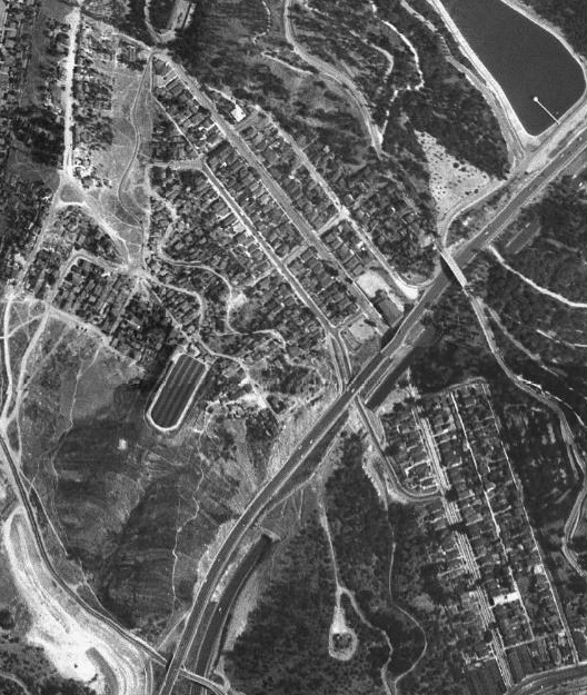
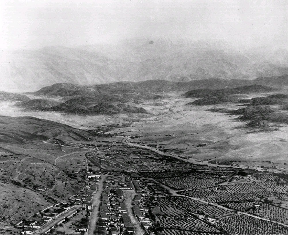
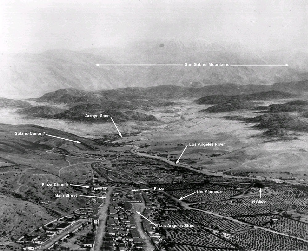
The original Solano Avenue elementary school (r) and the new school (l) in 1923
In the photograph above, the original Solano Avenue school is the large building on the right, facing Solano Avenue.  The vacant lot across the street served as the playground for the school.  Across Yuba Street to the left is the new Solano Avenue school, which is the current school.  Also identified in this photograph are Casanova Street (top) and Amador Street (bottom), with Solano Avenue running roughly horizontally through the middle of the photograph.

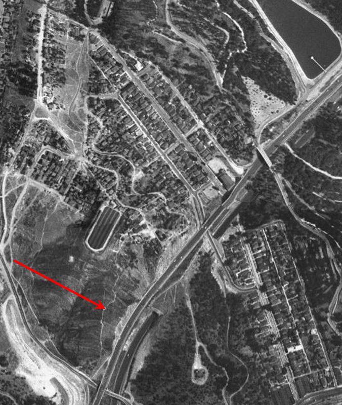
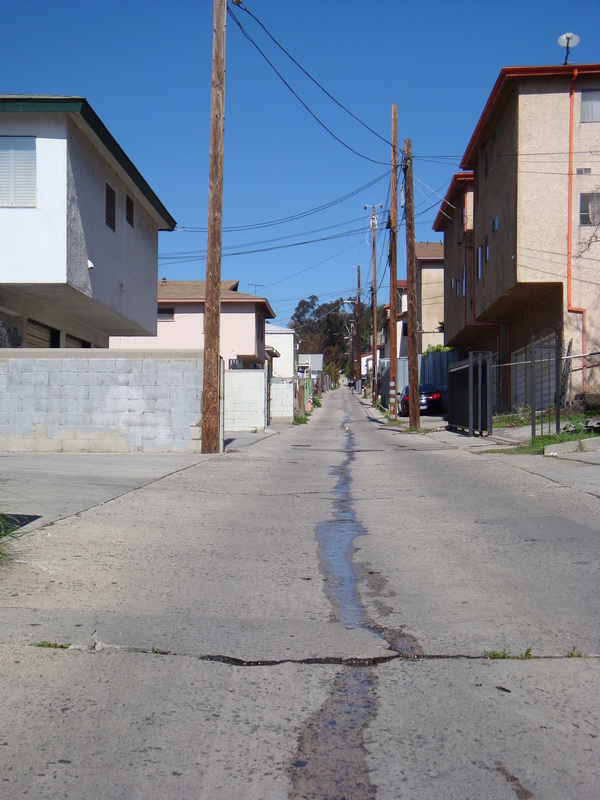
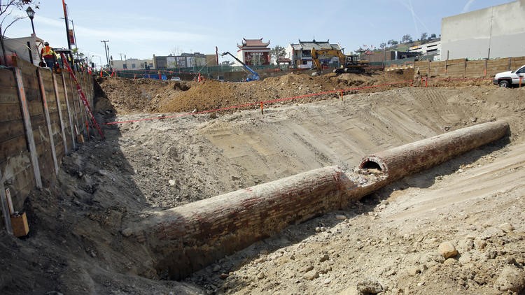
The original school is torn down

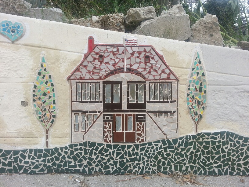
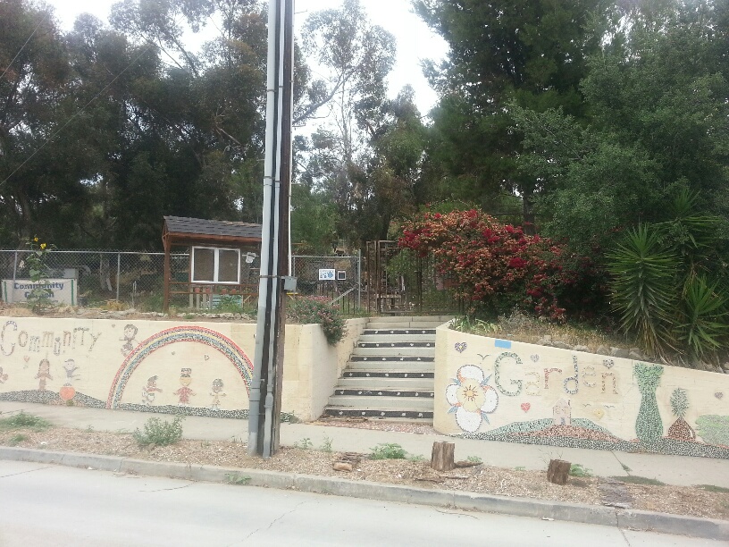
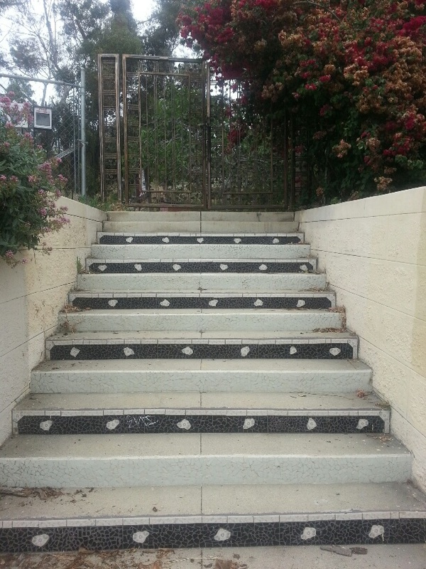
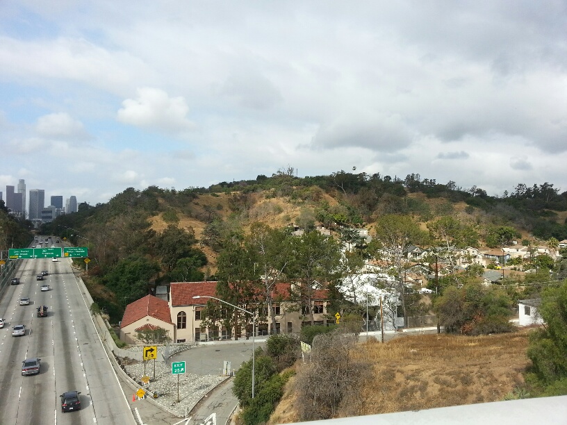
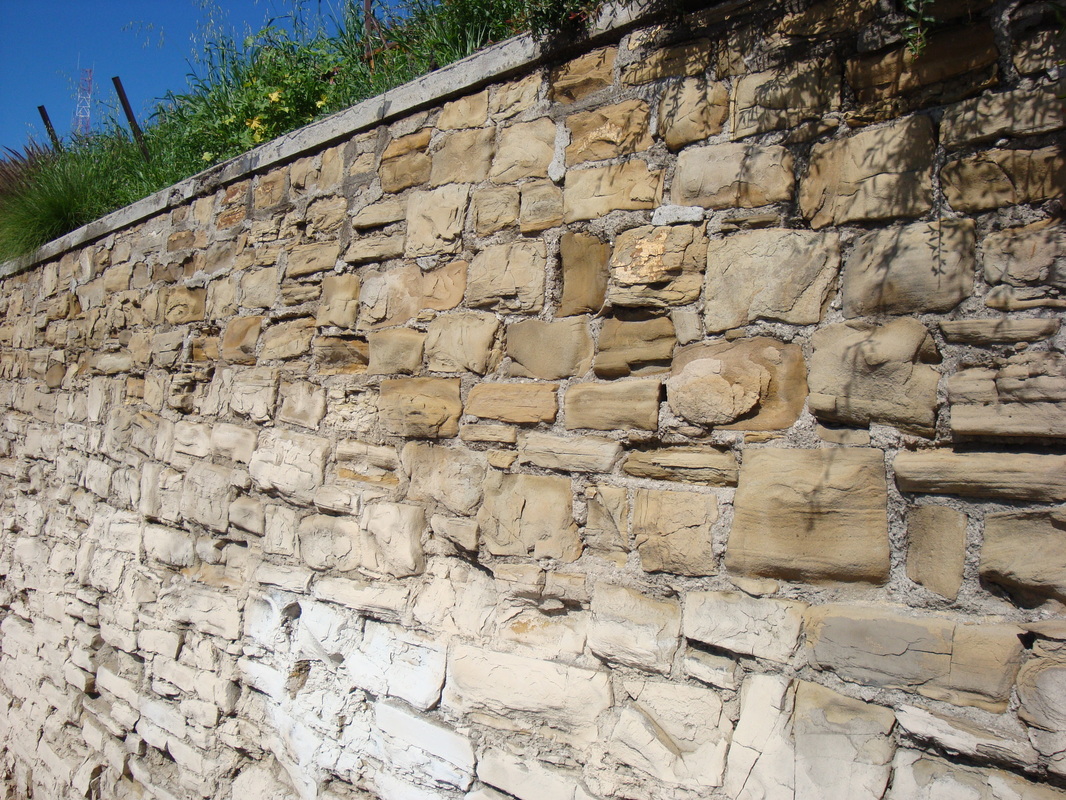
The original Solano Avenue school was eventually replaced by the new school shown in the photograph above and was torn down in 1935 as part of the construction of the Pasadena Freeway, now CA-110.  Parts of the foundation, a retaining wall and the concrete stairs leading up to the school remain, however, as the retaining wall of, and entrance to, the five-acre Solano Community Garden.

A personal connection to the school

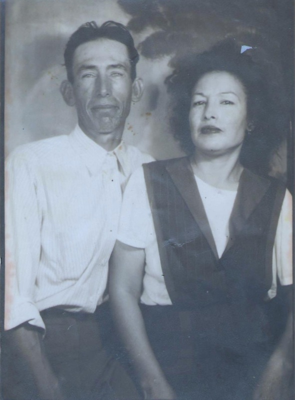
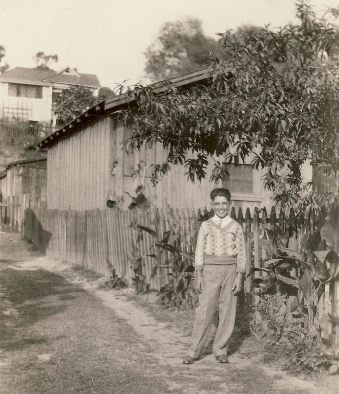
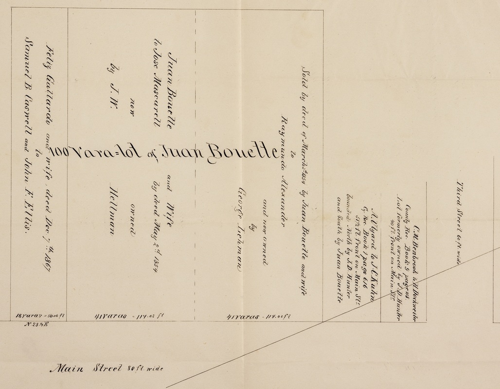
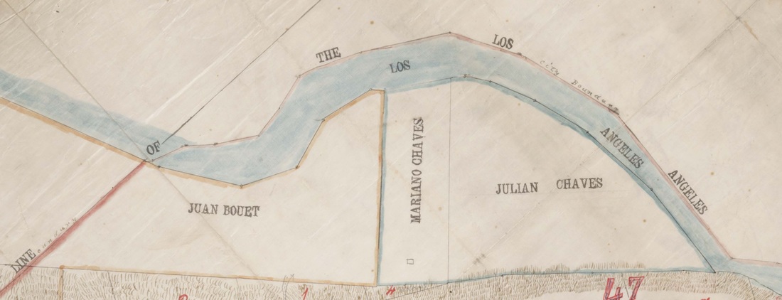
In 1903, when the original Solano Avenue school was built, the author's grandfather, Teodoro Manuel Bouett, grandson of Solano Canyon founders Francisco Solano and Rosa Casanova, was living with his parents, Maria Agustina Solano and Guillermo Bouett, and his four surviving siblings at 1425 Buena Vista Road, now North Broadway, on the corner of Buena Vista Road and Casanova Street.  He was eight years old.  After the new Solano Avenue school opened, Teodoro Bouett became a student there.  Then, in 1920, my father, Guillermo Carlos Bouett, son of Teodoro, became the second generation of his family to attend the Solano Avenue school.

Guillermo Bouett attended Solano elementary between September 1920 and June 1926, from the 1st through the 6th grades.  The following table lists his teachers and principals during that time, compiled from his original report cards.  In addition, other known teachers and principals are listed, along with their dates of service.

Year

Grade

Teacher

Principal

1903-04

All

Addie J. Samuels

Addie J. Samuels

1904-05

?

Clara E. Heald
Mary L. Small

1905-06

?

Mary L. Small

1920-21

1st

Estella Thompson

C. G. Hopkins

1921-22

2nd

Leah Robbins
Mabel C. Moore

1922-23

3rd

Ethel R. Merrill

1923-24

4th

Esther Helm

1924-25

5th

M. G. Jones

1925-26

6th

V. Self

Orra Leta Hendrick


Bill Bouett Report Card
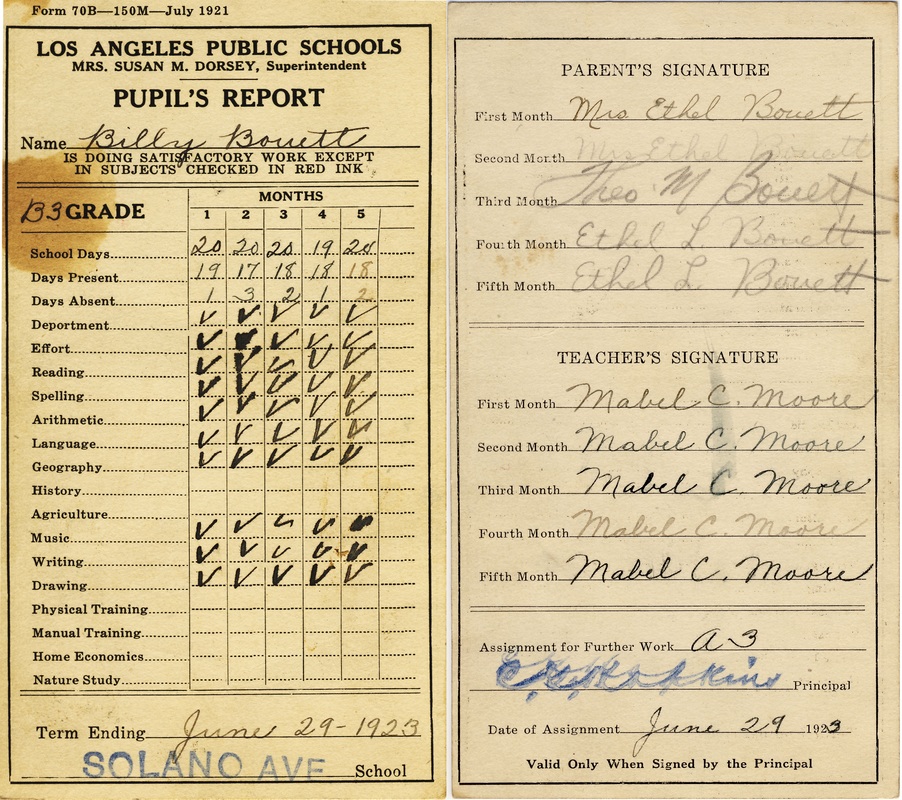
1923 Report Card from Solano Avenue School
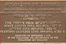

A teacher-principal database, anyone?

If there are those of you who attended the original Solano Avenue school or would like to know more about who taught there and when, including the principals, I will be happy to continue to compile this database -- just let me know.

Solano Avenue elementary school today

Picture
The 'new' Solano Avenue elementary school today
Comments

Community Service

6/3/2015

Comments


Service or hypocrisy?

Los Angeles City Council districts are large areas and each includes several communities.  Within our communities, we probably tend to feel that our City Councilperson exists to serve only us.  While it is true that there may be district-wide issues within each district, it is also true that there are community-wide issues that are unique to each community, and which are not district-wide issues.

Traffic on Solano Avenue in the Solano Canyon community is one such local issue, and it is one that is apparently not being adequately addressed, at least according to many of the residents of Solano Canyon.

This is the area near Solano Canyon.  Notice the hulking presence of Dodger Stadium, whose existence has been the subject of several blogs, on both this website and on the Chávez Ravine website.  In particular, see the recent blog, A Disaster Waiting To Happen.
Dodger Stadium and Solano Canyon
This is the location of the Solano Canyon community.
Solano Canyon identified


Stadium traffic on game days

This is the route that stadium traffic that uses Solano Avenue for access to Dodger Stadium must take on Dodger game days.
Game-day traffic
The yellow arrows point to traffic traveling both northeast and southwest on North Broadway.  The red line is the tortuous route that that traffic must take up Solano Avenue to the 500 block; then, after making a hard left-turn onto Amador Street, it follows Amador to an "S" curve (Amador Place) that empties once more onto Solano Avenue, which then merges with, and becomes, Academy Road, and which eventually provides access to the Dodger Stadium parking lots through the Academy Gate (Gate D).  Approximately 10% of stadium traffic on game days uses the Academy Gate.

In truth, however, this picture is itself incomplete; there is yet additional  traffic that empties off of southbound CA-110 (upper yellow arrow) onto 30-foot-wide Academy Road (white line), which is actually nothing more than an extension of Casanova Street, an original street in Solano Canyon that dates from 1888.
Add Casanova Street


CD-1 and LADOT devised a plan

Former City Councilman Ed Reyes of CD-1, after listening to the complaints of the residents of Solano Canyon and working closely with them, came up with a traffic mitigation plan that was approved by the City Council in 2013.
2013 DOT plan
Now, Dodger Stadium has five gates that provide access to various areas of the vast stadium parking lots.


Other access to Dodger Stadium

Bouett Street closure
The purpose of this plan, which was explained in detail in the blog A Disaster Waiting To Happen, was effectively to close Solano Avenue to Dodger Stadium game-day traffic.  In addition, and somewhat bizarrely, a one-block segment of Bouett Street was also closed, although rarely did any stadium traffic fail to make the "S" turn on Amador and instead continue up Amador to Bouett Street, which then required a full stop at Bouett, followed by a hard-right turn onto Bouett and another hard stop at Solano Avenue; and, finally, a hard-left turn onto Solano Avenue, which would have been solid with stadium traffic that was not likely to yield to allow cars to enter onto Solano from Bouett.  That strange closure is the short, white line marked with a red "X".
Picture
Of the five access gates, the preferred gate, according to the City and the Dodgers, is the Downtown Gate (Gate E).  Other gates are the Sunset Gate (Gate A), the Stadium Way Gate (Gate B), also popularly known as the Scott Gate, and the Golden State Gate (Gate C).
Interestingly, the Scott Gate was closed for a time, due to complaints from the residents of Echo Park about excessive traffic in their community on game days (does that sound familiar?).  Although the Scott Gate is once again being used, the residents of Echo Park have achieved a modicum of relief by restricting parking on several of their streets.  (See the blog, "Equal treatment under the law?" on this website.)  It should be noted that Echo Park residents live in CD-13; Solano Canyon residents live in CD-1.


Don't complain; solve the problem!

We all know that it is easy to complain; it is another thing altogether to solve the problem.  While there may not be an easy solution to the problem of game-day traffic through Solano Canyon, there may exist more than one solution.

One such solution is to enforce the City Council-approved DOT plan to limit — if not eliminate — stadium traffic through the Solano Canyon community on Solano Avenue on game days.  It is known for certain that there continues to be an ongoing dialog with CD-1 staff about this issue; but, to date, community efforts at a solution have been met with delay and obfuscation.

Or how about simply making better use of the existing Downtown Gate exit from CA-110 that empties directly onto the access road to the Downtown Gate, which both the City and the Dodgers profess is the preferred access gate to the stadium?  That would eliminate — eliminate, not simply reduce — game-day traffic on Solano Avenue.

Why not try to think outside the box for a change?

One solution
Here, the lower red "X" shows Solano Avenue closed to game-day traffic; the upper red "X" shows the same for the Academy Road exit from CA-110; and the red arrow shows the existing exit from CA-110, one that delivers game-day traffic directly to the Downtown Gate.

It's just a thought ...
Comments

Lupe and Pilar García

5/26/2015

Comments


A la Loma family story
A new beginning; displacement; and heartbreak

On Sunday, I told the story of how the man on the cover of Don Normark's classic book, Chávez Ravine, 1949:  A Los Angeles Story, was positively identified by two of his daughters as Guadalupe García.  Today, I will tell you a little about Lupe's family and the relatively short time they lived in la Loma, one of the Chávez Ravine communities that was destroyed during the 1950s to make way, eventually, for the construction of Dodger Stadium.

It is a story of one family's new beginnings — first by a happy, new life in the Chávez Ravine community of la Loma, then followed by displacement and the heartbreak of eviction at the hands of their adopted city, Los Angeles.

Meet Guadalupe García and Pilar de León

Lupe and Pilar
Guadalupe García and Pilar de León [photo courtesy the García family]
This lovely photograph of Lupe García and Pilar de León is undated; but if there is any doubt about the identity of the man on the cover of Normark's book, compare this photo with the one in the blog Who is this man?.

Lupe García was born in 1913 in México, probably in Aguascalientes, although his birth record has not been located.  He is the son of Librado Garciá and his wife, Juanita.  Pilar de León was born in 1912 in Goliad County, Texas, the daughter of Juan de León and Carlota Bocanegra, who are from México.  In the 1930 US census of Texas, Lupe and Pilar are found living near each other in rural Edna, jackson County, Texas.

Lupe's parents, Librado and Juanita, immigrated to the United States in 1916, when Lupe was a small child.  They had been married 32 years in 1930, and their last child, David, was born in Texas in 1918.

On the other hand, Pilar de León's parents, Juan and Carlota, immigrated in 1887, when they were both very young, and so they must have married in Texas.  They were the parents of nine children, three girls and six boys, born between 1910 and 1928.   Pilar was their second child; she has an older sister, Luisa.

Lupe and Pilar married sometime between 1930 and 1935.  Over the next seven years, they had four children:  Mary Ann (1935), Guadalupe Gilberto (a boy, 1938), Madalena (known as Helen, 1940), and Librado D. (1942).

From Texas to Los Angeles

In 1945, Lupe and Pilar and their four children moved from Port Lavaca, Texas, to Los Angeles, settling temporarily with the de León family, Pilar's parents, Juan and Carlota, on Amador Street in Solano Canyon, sharing the house with three uncles who were recently returned from World War II, and others.  As Helen tells it, "I remember lots of people living there."
"I remember lots of people living there."  — Helen García
Shortly after their arrival, the García family moved to "... a small house behind the mission ...", according to Helen.  The mission she refers to is the San Conrado Church on Bouett Street in Solano Canyon.
"It was near the church."  — Mary Ann García

The family moves to la Loma

After living for a short time in the small, rented house behind the San Conrado Mission, Pilar located a two-story house on Spruce Street in la Loma, and the family moved once more.  The address of the house is not known with certainty, but it must have been in the 600 block.  The house was on the downhill side of Spruce Street and faced the street.  The lot went all the way to Phoenix Street and Helen says she remembers walking down the hill to attend Solano Avenue School.
"My mother had a friend, Mrs. Trujillo, who lived on Amador Street or Solano Avenue — I'm not sure — and it turned out that Mrs. Trujillo's daughter [Molly] married my uncle Elías.  Anyway, while that romance was going on, I got to know Mrs. Trujillo, and she would take me, once a week, downtown to the Mexican movies on Broadway."  — Helen García


Helen Garcia identifies her house

la Loma from Solano Canyon
A view of la Loma from Solano Canyon, circa 1930
Helen García noticed this photograph from an earlier blog, A Tour of Chavez Ravine in Under 2 Minutes.  The García home on Spruce Street is the two-story, white house near the top, left-hand corner of the photograph — the house that is partially obscured by a tree.  This is the house she identified as the family home on Spruce Street in la Loma.
The Garcia house on Spruce Street
The García house on Spruce Street in la Loma


Shangri-la becomes not-so-pleasant

The García family lived on Spruce Street in la Loma for nearly five years.  Helen García remembers fruit trees growing below their house, especially loquat, apricot, and sapote, which was Helen's favorite.  She also remembers the sound of bells on the goats that were kept further up the street, and of her playing on the street in front of the house.
"It was a playground to me ... I was sad to let go of the house and move."  — Helen García

"We were very happy there."  — Mary Ann García
Then, one day in 1950 or 1951, a man came to the house to tell the family they had to move.  It was the start of what became the eventual eviction and destruction of the homes of nearly 1,100 families in the Chavez Ravine communities of la Loma, Palo Verde, and Bishop.  Helen, then ten years old, doesn't remember much about the visit that day; but Mary Ann, Helen's sister and nearly five years her senior, has a vivid memory of the man and that time.
"All of a sudden, this man came over and said we had to go — we had to leave.  He was Anglo, tall, thin; he had a mustache.  He spoke with a brusque voice so that we would be afraid of him.  He introduced himself, but I don't remember his name.  I got angry, to think that someone like that could take our home away ... He said, 'We have to take your home away, because the military wants to use it for some training.'  He offered us $1,000.  I said, 'No, we need more money than that', so he said, 'Well, then, $2,000'.  I was so upset I had to leave.  I knew if I didn't get out of there, I would do something, I was so mad.  I don't know what [my parents] eventually got for the house."  — Mary Ann García
The perception of sixteen-year-old Mary Ann García paints a disturbing picture.  She saw the tall, thin Anglo man with a mustache as a threatening figure who was trying to intimidate her parents into selling their home for very little money.  How much money they eventually received for their house is not known, but Mary Ann's memories reveal a determined and heavy-handed effort to get nearly 1,100 mostly-Hispanic families off their properties

What was the real purpose of the evictions?  Was there perhaps a racial component to the plan?
"Years later, that house stood for so long, and here they didn't even do anything with that property.  You could see the house from the freeway.  We would always look over and see the house.  For many years, I would see it there; then, all of a sudden, it was gone.  It was a tiny little house, but it was a nice house."  — Helen García

An afterword

First-person accounts carry incredible power.  My thanks to sisters Mary Ann and Helen García for their memories and for their recorded accounts, and for their gracious permission to publish them here.

Update

Shortly after I published this blog about two hours ago, a dear friend of mine who lives in Solano Canyon sent me this photograph.  Compare it with the 1930s-era photograph, above.  More than 50 years after the evictions and the destruction have all been said and done, this is what la Loma looks like today — it's the same location as in the photographs, above.  And it's a shame.
la Loma, 2015
la Loma from Solano Canyon, 2015
Comments

Who is this man?

5/24/2015

Comments


Chávez Ravine, 1949
A Los Angeles Story by Don Normark

Chávez Ravine, 1949 cover

The mystery man on the cover

Anyone who has ever viewed Don Normark's now-classic 1999 volume of photographs and text, Chávez Ravine, 1949, A Los Angeles Story, has marveled at the iconic photograph on the dust jacket of a solitary man — a workman, perhaps — wearing a hat and carrying a lunch box and walking along a winding path toward a cluster of houses and, presumably, toward home.  Portions of the image are repeated on the front cover of the book and again on page 55.  It is a captivating image; but the man's identity is not revealed in the book.

Recently, a Seattle resident, Victor Rini, Googled 'Chavez Ravine' and was surprised at the amount of information he found there, including about the PBS 2003 Independent Lens documentary CHAVEZ RAVINE by Jordan Mechner.  One of Normark's images from the book appeared briefly in the film

Victor continued searching the Web for Normark's images, and he found these two:
Studying the two images, Victor thought, That looks like my grandfather, Lupe García.

On Mother's Day, 2015, he was able to show the images to his mother, Helen.  Her reaction was immediate:

"That's my father!" she said emphatically.

The following weekend, the images were shown to Victor's aunt and Helen's sister, Mary Ann.

"That's Dad!" she said.

And so it was confirmed by two of his daughters:  the image in the Normark book, and the second image, also taken by Normark, which shows the man from the front, is of la Loma resident Guadalupe García.

Mystery solved!


Where was Lupe García walking?

But the questions asked by many of us remained:  where was the path on which he was walking located, and to where was he going?

To try to solve that puzzle, I turned to a 1948 aerial photograph of the area:
1948 Aerial Photo
Portion of Los Angeles, 1948
Knowing where to look, I zoomed in to this area:
1948 photo, Solano Canyon area
Portion of the 1948 aerial photograph
This portion of the 1948 aerial photograph, while still quite busy, clearly shows all of Solano Canyon and la Loma as it appeared in 1948.  But where is the path?

The García family lived on Spruce Street in la Loma.  Victor's mother, Helen, described in detail the location of the family's home in relation to the topography of the area.  She also described how she walked, once every week, down the same path that her father walked every day to his job as a stevedore for the Southern Pacific Railroad.  She said that the path led down to Bishop's Road, and from there, she continued on to Savoy Street, where she took piano lessons in the Ocampo home from Professor Cantu.

Armed with this information, I located Bishop's Road on the photograph (it is the curving street at the bottom-left of the image).  The path had to connect Spruce Street, in la Loma near the reservoir, with Bishop's Road.

And there it was:  the path.
The path, annotated
The path from la Loma to Bishop's Road, 1948


The mystery is solved

So, through a series of coincidences, the least of which is not the fact that Victor knew of my blogs and went to the trouble to contact me, the mystery of the identity of the man on the cover of Don Normark's book has been solved.  In future blogs, I will discuss more about the García family history and genealogy.  It is an interesting story.

My many thanks to Victor; to his mother, Helen; and to his aunt, Mary Ann, for permission to present this information.


One final puzzle

There was one final puzzle that bothered me about  Normark's photogarphs of Lupe García:  why, in the photograph of Lupe's walking away from the camera, was he wearing suspenders, while in the photograph of his walking toward the camera, he was not?

I posed that question to Victor, who quickly answered it for me:  Lupe was a stevedore, and the "X" mark on his back was not suspenders; rather, it was sweat marks on his shirt from the straps on the apron that he wore while at work.
Comments

Equal treatment under the law?

5/22/2015

Comments

 
The right to be treated equally under the law is fundamental to American society.  It is probably safe to say that no one believes that he or she should be treated less-well than any other person.  We all know that, unfortunately, the desire (indeed the right) to be treated fairly is not always reflected in the actual treatment one receives; however, the goal of fairness is a laudable goal that we should always keep in mind and try to live by.

We live by the rule of law

We live under laws that derive from many levels of government — Federal, state, and local, to name but a few.  Although local laws usually take the form of ordinances, they are effectively laws, nevertheless.

One such ordinance is Los Angeles City Ordinance 183135.  This ordinance, effective on 08 July 2014, primarily governs parking issues at major sports and entertainment events in the City.  Interestingly, the ordinance specifically mentions "... events at major sports and entertainment venues, including Dodger Stadium [my emphasis] ...".  Two sections of the ordinance are of particular interest and warrant further inspection.  The Transportation Committee finds that:
5.  [T]he unrestricted parking of vehicles in the residentially [sic] developed neighborhoods adjacent to Dodger Stadium is causing traffic congestion, is resulting in a detriment to the public welfare from complaints associated with a significant increase in the number of parked vehicles during Dodger Stadium events including blocked driveways, excessive noise at night after the games, excessive litter and consumption of alcohol in vehicles, and is interfering with timely emergency vehicle access to and from the streets and residences in these neighborhoods for both Police and Fire Departments.
Further, the Committee finds that:
6.  [E]vents at major sports and entertainment venues, including Dodger Stadium, are defined as a Special Event by LAMC Section 41.20.1, and that the policy for Special
Events at these venues, is specified in LAMC Section 41.20.1.(c).
In other words, Dodger games are 'special events' under the provisions of this ordinance, and they are therefore subject to the provisions of the ordinance.  The ordinance goes on to say that the Los Angeles Department of Transportation (LADOT) is authorized to establish appropriate signage for such events and directed [i.e., required] to establish procedures to ensure the provisions of the ordinance are met.

Who is most affected adversely by Dodger Stadium game-day traffic?

Residents of two communities in particular — Echo Park and Solano Canyon — have long been seriously adversely affected by Dodger Stadium game-day traffic moving through the streets of their neighborhoods.  What is meant by 'adversely affected' is that local streets have been used for ingress and egress to- and from the stadium on game days, a purpose for which they were not designed.  The ordinance is specific in its description of the problems caused by this situation:
  • a significant increase in the number of parked vehicles [in local communities] during Dodger Stadium events;
  • blocked driveways;
  • excessive noise at night after the games [think also:  Friday night fireworks];
  • excessive litter; and, perhaps most important in terms of public safety,
  • [interference] with timely emergency vehicle access to and from the streets and residences in these neighborhoods for both Police and Fire Departments.
I would add one further bullet-point that was not enumerated in the ordinance, but which has been a point of contention with residents for years:
  • public urination.

What Echo Park has done

The community of Echo Park has, to its credit, already made use of the provisions of this ordinance.
Echo Park signage
In this photograph, a dozen happy residents (along with three dogs) are giving a hearty 'thumbs-up' for the signage above them on the lamppost.  But what does the signage, about which these residents are so happy, actually say?
Close-up of EC signage
The top (red) portion of the sign says,

NO PARKING ANY TIME DURING STADIUM EVENTS


Baseball games at Dodger Stadium are 'stadium events'.  OK, Dodger fans traveling to games in their cars cannot park on the marked streets in Echo Park.  The middle (green) portion says,

VEHICLES WITH DISTRICT 'D' PERMITS EXEMPTED

What is a 'District D' permit?  It's a permit that residents may obtain that allows them to park on the streets of their own community near their homes.  That's a nice touch.

Finally, the lower (yellow) portion of the sign says,

ENFORCED 4 HOURS BEFORE STADIUM EVENT TO END OF EVENT

What this all means is that, beginning four hours prior to any baseball game at Dodger Stadium, no parking on the marked streets in Echo Park is allowed for vehicles that do not display a resident permit.

This is excellent.  If the signage is obeyed — or, more to the point, if the rules elaborated on the signage are enforced — then the residents of Echo Park will have achieved some measure of peace within their community.

Is this victory?

Good for Echo Park!  But is this truly victory over the perennial problem of Dodger Stadium game-day traffic?  Not so fast ...

Remember, under the rule of law, what applies to one applies to all.  So what about the residents of Solano Canyon, who have been complaining about Dodger game-day traffic for as long as have the residents of Echo Park?  Echo Park is in CD13; Solano Canyon is in CD1.  The two communities are served by different City Council members, who apparently have differing priorities.  The 'bottom line' here is that Solano Canyon has yet to be granted any relief from Dodger Stadium traffic, even though there has been a DOT plan in place since 2013 to mitigate traffic on Solano Avenue from North Broadway on game days.
N Broadway DOT Plan
In practical terms, the DOT plan, above, has been abandoned, and in fact,  it was never rigorously enforced (see my blog, A Disaster Waiting to Happen).  Solano Canyon has never been granted any relief from Dodger Stadium game-day traffic.

What's a Solanero to do?

It would seem that there is but one thing to do:  complain, loudly and vociferously, to Gil Cedillo, the City Councilman for CD1.  One voice may, in fact, seem very small when pitted against a powerful and (apparently) disinterested force; but many voices — voices that reinforce each other — produce a sound of great volume that has a power that, in the end, cannot be ignored.  Solano Avenue and Casanova Street are not — and should never have been — conduits for traffic to Dodger Stadium.

And remember:  what is made available to one community should be made available to all communities.

More to come ...
Comments

Solano Canyon on 'Mad Men'?

5/6/2015

Comments

 
Well, no, not exactly.

In the blog Alfred Solano, patron of Solano Canyon that was posted on April 26th, there was a photoragph of Stimson House, the 30-room mansion at 2421 Figueroa Street that Alfred and Ella Solano purchased in 1904 from the estate of the builder and original owner of the house, Thomas Douglas Stimson.  This is the contemporary image that was used in the blog:
The Castle
Stimson House, or "The Castle", 2421 S. Figueroa St.
Now, I had never seen the AMC drama series Mad Men; so, in an effort to keep up with the times, I have been watching the series.  In Season 5, Episode 3, which is entitled "Tea Leaves", something caught my eye so powerfully that it brought me to full-stop.  I hit the PAUSE button and scrolled back.  In this scene, Henry Francis and his wife, Betty, the former Mrs. Don Draper, and Betty's three children are sitting on the front lawn of their home.  Here is the screen capture of that moment, which occurs at 33:49 of the episode:
S5E3, 33:49
"Mad Men", season 5, episode 3, 33:49 [AMC]
The family is sitting on the lawn in front of The Castle!  OK, so the production company paid the current owners of the mansion, the Sisters of St. Joseph of Corondolet, to film the outside of the mansion; that sort of thing happens all the time in Los Angeles, right?

Although I have visited The Castle several times, I have not seen the interior in person.  Chapter 5 in the book, Los Angeles's [sic] Chester Place, entitled "The Castle", describes the mansion in some detail and has several photographs of its interior, including this one on page 102:
Chester Place p 102
Page 102 from "Los Angeles's Chester Place"
Nice, I thought, I'd love to see the inside of the house myself.  A few minutes later into the same episode of Mad Men, at 37:06, there was this scene of Henry and Betty:
S5E3, 37:06
"Mad Men", season 5, episode 3, 37:06 [AMC]
This scene was clearly filmed inside the mansion.  So the AMC production company of Mad Men not only got to use the grounds of the mansion as background, they got to film inside, too!  (This is the front entry hall; the main parlor is to the left.)

And all this for a television drama that is supposed to take place in New York!

I realize this has nothing to do with Solano Canyon directly, but I thought since I had already posted a photo of the house on the blog about Alfred Solano, I would go ahead and share this bit of television trivia with you, too.
Comments

Solano Canyon in 1850?

5/4/2015

Comments

 
We all know that the land that is now the Historic Solano Canyon community was purchased by Francisco Solano in 1866.  So how was there a Solano Canyon in 1850?  (The ravine was there, of course, but it didn't have a name in 1850.)

The answer is:  there wasn't.  But this "... photograph of an accurate model of Los Angeles in 1850 ..." provides us with a rare opportunity to envision the land that eventually did become Solano Canyon — 16 years later.

Here is the original image as the author found it online, with no annotations; see how many Los Angeles-area features you can locate and name.  There are at least nine prominent features, with a tenth that is tantalizingly suggestive.  Many more features can probably be found as well.
LA 1850
Uncredited image
So, how did you do?  I'll tell you that I only found four; but here is the same photograph, this time annotated to locate the nine features that were identified in the notes for the photograph.  I've added that 'tantalizingly suggestive' tenth feature and marked it with a question mark.
Annotated LA 1850
Uncredited image [Annotated by the author]
A word of explanation:  The original image, above — the one at the top of the blog — was found on the Water and Power Associates website.  The image is 'credited' there to yet another website, but the author was unable to find it there at all.  And what is meant by "... photograph of an accurate model of Los Angeles in 1850 ..."?  Is this a photograph of a model?  If it is, then it is a highly-detailed one, because it looks like a photograph to me.  But if it is a photograph, from where was it taken?  A balloon, perhaps?

In any case, it's an interesting exercise, I think, and I hope you had fun with it.
Comments

The Day the Alley Ran Red

5/2/2015

Comments

 
The following story was received in a letter to the author from his father in 1980.  The story is told in his father's own words.
Solano-Casanova Alley
The alley that ran red in 1925 [Image: Lydia Moreno]
THE DAY THE ALLEY RAN RED

     This may sound like a gruesome title, but it is a lot different than it may seem.
     The year was somewhere between 1925 and 1927, and Prohibition was in effect.  Many of the residents on Solano Avenue and Casanova Street were Italian, and they always made their own wine.
     Somehow, word got around that there was going to be a raid by Federal Prohibition Officers.  This was important news, because at that time, making wine was strictly illegal and the residents either had not, or could not, pay the taxes to make wine for their own use.
     Anyhow, word got around that there was going to be a raid, so the Italians started to dump their illegal, homemade wine into the alley.  The alley was made of concrete and it was about 12 feet wide with a slight "V" in the middle.  So as a result of all the wine being dumped into the alley, there was a very good flow of Red Wine down the middle of the alley.
     Other residents must have heard what was going on, because there were people up and down the alley scooping up the wine, putting it into bottles, and leaving quickly.


Bill Bouett 1923Bill Bouett, ca. 1923
Guillermo Carlos Bouett, known almost his entire life as 'Bill', was born in 1915 on Avenue 32 in Los Angeles and was baptized in the Plaza Church.  Before he was five, Bill Bouett moved with his parents to a house at 427 Solano Avenue in Solano Canyon, where he lived for more than a decade before his family moved again, this this time to Alhambra.  The incident described above occurred about 1925 during Prohibition.

The image at left was taken about 1923, a few years before the raid described in the story.  In the image, eight-year-old Bill Bouett stands beside his family's home on Solano Avenue.  In the background, higher up on the loma, one can see one of the houses on Casanova Street.  The 'alley that ran red' is located between the two streets.


— Lawrence Bouett
Comments

Alfredo Solano, patron of Solano Canyon

4/26/2015

Comments

 
Alfredo Solano, or Alfred as he was known for most of his adult life, was born in Los Angeles 02 May 1857, the second child and first son of Francisco Sales de Jesús Solano and María Rosa de las Mercedes Casanova, immigrants from Costa Rica about 1850.  He died, also in Los Angeles, 14 November 1943 at age 86.  He was married three times, to Ella T. Brooks, Minnie Belle Classey, and Kathryn E. Hathaway, and he produced no children.  He is buried at Forest Lawn cemetery in Glendale, California.
This is the first of a series of blogs that will feature the lives of  "People of Solano Canyon" — individuals who are important to the development of the Solano Canyon community — from its founding in 1866 to the present day.  More may be read about these Solano Canyon champions on their individual pages under History, People of Solano on this website.
Alfred Solano grave marker
Photo: Lydia Moreno
George Hansen, ca. 1870George Hansen, ca. 1857 [Anaheim Public Library P457]
A wag once said that the point to life is to make the distance between the dates on one's tombstone as great as possible; but it seems to me that it is the quality of what lies between those dates that is what really matters.  By the latter definition, the life of Alfred Solano was a full one, and one that truly mattered.

Alfred's parents immigrated to Los Angeles from Costa Rica sometime between November 1847, when Rosa Casanova's youngest sister, María Teodora, was baptized in Costa Rica, and April 1850, when her father, Antonio Casanova, died in Los Angeles of bronchitis.  [Click here for an example of how a family story that has been passed down from generation-to-generation can be completely misleading even though it contains a grain of truth.]

Alfred
is found in the 1870 census, at the age of 14, living in the household of George Hansen and Hansen's long-time, live-in housekeeper, Francisca García.  In 1880, the two men were lodgers in the home of J. S. Crawford, a Los Angeles dentist and a widower.  Exactly when, and how, Alfred made Hansen's acquaintance is not known; but Hansen was a surveyor and civil engineer, and it is likely that Alfred took an interest in the work.  Hansen became Alfred's mentor, and the two of them went into the surveying business together as Hansen & Solano, an arrangement that was maintained until Hansen's death in 1897.  When he died, George Hansen left his entire estate to Alfred.  Alfred is referred to in several places and at different times as Hansen's ward, although whether that is true in a legal sense is not known.

Hansen & Solano advertisement
Advertisement, 1883 [Los Angeles Herald]
In 1875, George Hansen and his protégé, Alfred, left Los Angeles by steamer and traveled to San Francisco.  The following day, they took the ferry across San Francisco Bay to Berkeley, where Alfred was introduced to the Chancellor of the University of California.  As a result of that meeting, Alfred was enrolled in the Engineering College.  He began his civil engineering studies in Berkeley at the start of the next term, but he probably only attended for one or two semesters before returning to Los Angeles, apparently homesick.  There is no record of his course of study, nor of whether he graduated.

Whether Alfred ever lived with his parents and siblings in the adobe that his father build on the stream in what became known as Solano Cañon — later Solano Ravine — is not known, but after his father died in 1871, it is known from his diaries that Alfred helped care for the needs of his mother, Rosa Casanova, and his five siblings:  Josefina, Alejandro, María, Manuel, and Alonzo.  In one entry, he documents his having purchased two bibles, one for each of his two sisters.  One of the bibles was destroyed in a house fire about 25 years ago; the other one is still with a descendant, and which the author has seen.  It contains some valuable genealogical information.

Alfred took pains to preserve the 87 acres of land that his father had purchased from the City of Los Angeles in 1866.  He refers in his diaries to his awareness of the value of his family's retaining the land as a legacy.  At the same time, he threw himself into his surveying work with George Hansen as well as the social scene in Los Angeles.

He was one of the founding members of the Los Angeles Athletic Club (LAAC) and, in what may be the only extant photograph of him as a young man, Alfred was a member of the LAAC baseball team in 1884.  Alfred is the person in the back row, at the far left.
CHS 8623
LAAC Baseball Team, circa 1884; California Historical Society 8623
After Alfred married the widow, Ella T. Brooks, in 1886, the couple quickly rose to prominence in Los Angeles social circles.  They built a large mansion on Figueroa Street at 23rd Street in 1896 and, in 1904, they purchased the 30-room Stimson House, which still stands at 2421 South Figueroa Street.  They entertained lavishly and Alfred acquired considerable political influence, although he never ran for political office himself.  It was partly that political influence and the respect with which he was held by the City Council that allowed him to be a responsible conservator or his parents' land in the Stone Quarry Hills.  He was, at various times, Assistant City Surveyor and City Surveyor of Los Angeles, and County Surveyor of Los Angeles County.
Although Alfred never lived in Solano Canyon — at least, not as an adult — he is nevertheless the single person who is most responsible for the existence of the Solano Canyon community today.

This is one of only a small handful of snapshots of Alfred Solano as an adult.  This photograph was taken in the Palo Verde Valley in Blythe, California about 1930.

Alfred ca 1930
Alfred Solano in the Palo Verde Valley, Blythe, California, circa 1930
Alfred Solano did many other interesting things in his life.  He taught mining engineering at USC in 1918 (the author has one of his examinations), prospected for minerals in California and Arizona and gems in South America (the author has an emerald ring made from one of the stones Alfred brought back), and he told the author's father that he was with Jimmy Angel when Angel accidentally discovered Angel Falls, the world's highest waterfall, in Venezuela in 1933; Alfred was 75 years old at the time.
Angel Falls
Angel Falls, Venezuela
Angel Falls has a 3,212-foot total drop, with a free drop of 2,648 feet.  It is worth watching this video of Angel Falls, and reading this article.
This fall is named for Jimmy Angel, an adventurous pilot from Missouri, United States, who flew to the air circus Lindberg. James Crawford Angel (Jimmy Angel) is a modern legend. He saw the waterfall for the first time in 1933 with his partner while searching for the legendary McCracken River of Gold, or the Golden City.
Jimmy Angel's partner mentioned in the article is Alfred Solano, patron of Solano Canyon.
Comments

My Spanish-California Roots:  Why Solano Canyon Means       So Much To Me

4/25/2015

Comments

 
Picture
A personal family journey

This blog is about my own family history and why Solano Canyon means so much to me, 246 years after the first of my ancestors came to California in 1769.  It is an attempt to explain why the 3/16 part of my blood that is Hispanic has become the most important part of my ethnic heritage and the part of which I am the most proud.  I hope you will share this journey with me.

José Manuel Pérez Nieto

Manuel Nieto was born circa 1734 in
la Villa de San Felipe y Santiago de Sinaloa, Nueva España, more commonly called simply la Villa de Sinaloa.  His mother is Manuela Pérez and his father is José Nieto.  In the 1790 padrón (census) of the Presidio of San Diego, Manuel Nieto, mulato, is listed along with his mother, Manuela Pérez, española, which means, in the rigid racial classification system in place at the time, that Manuel's father, who is not listed and is presumably dead by then, was black.  Manuel Nieto is the first of my ancestors to have come into what is now the State of California, as a soldier in the company of Gaspar Portolá.

Manuel Nieto married María Teresa Morillo, a native of Loreto in what is now Baja California, about 1775, presumably in Loreto.  They had six children, one of whom is a daughter, María Manuela Antonia Pérez Nieto.

María Manuela Antonia Pérez Nieto

Manuela Nieto was the fifth of six children of Manuel Nieto and María Teresa Morrillo.  She was
baptized at Mission San Gabriel in 1791.  When her father died in 1804, she inherited Rancho los Cerritos, one of the five ranchitos that once made up the vast Rancho la Zanja, the 330,000-acre grant of her father's from King Carlos III of Spain in 1784, the second of only four such royal grants in California.  The boundaries of the grand were defined as "... all the land between the San Gabriel and Santa Ana Rivers, and from the crest of the Saddleback Mountains to the sea."

Roque Jacinto de Cota

Roque Cota was born circa 1724 in the mysterious Villa del Fuerte in what is now Sinaloa, México.  He married Juana María Rita Verdugo in Loreto (now in Baja California) circa 1755.  They had 11 children, of whom, the fourth was Juan Ygnacio Guillermo, who was born in Loreto circa 1768, and of whom, more later.

Roque Cota was a soldado de cuera, a so-called 'leather-jacket' soldier in the Spanish Colonial army.  He was one of four soldiers who comprised the escolta (escort) who came to Los Angeles from Mission San Gabriel along with the 44 pobladores (settlers, literally 'residents') who first settled what is now Los Angeles, arriving September 4, 1781.  His name is memorialized on a bronze plaque in the Plaza of downtown Los Angeles, along with that of his younger brother, Antonio, who was also a member of the escolta.

Juan Ygnacio Guillermo Cota

Guillermo Cota was born circa 1768 in Loreto, the fourth of 11 children of Roque Cota and Juana María Verdugo.  He married first, María Manuela de Jesús Lisalde in 1794 at Mission San Gabriel Arcángel.  They had four children before Manuela died at Santa Bárbara in 1803.  Hers is one of the earliest burials in the Mission at Santa Bárbara.

Guillermo married, second, at Mission San Gabriel in 1805, 13-year-old Manuela Nieto, daughter of Manuel Nieto.  They had 13 children, of whom, the ninth was María Loreta Cota, born in 1824 and baptized in the downtown Plaza Church.

Guillermo Cota was alcalde mayor (mayor) of the Pueblo of Los Angeles three times:  1798–1799, again in 1824, and finally in 1827–1828.  He once had a large lot and an adobe house on Main Street.

Guillermo Cota lot downtown
portion of SR Map 0503, The Huntington Library
María Loreta Cota

Loreta Cota was born in Los Angeles and baptized in the Plaza Church in 1824, the daughter of Guillermo Cota and Manuela Nieto.  In May, 1847, when she was 22 years old, the ayntamiento (city government) granted her title to a 100-vara (278.1 feet) square lot downtown.  The property was located in what is now about 2/3 of the block between Main and Spring Streets and between Third and Fourth Streets, beginning about 90 feet south of Third Street.  She died a widow in Los Angeles in 1905.
SR Box 30, 15 (02)
portion of SR Box 30, 15 (02), The Huntington Library
Jean Bouet

Meanwhile in France, Jean Bouet was born in 1813 in Mont-de-Marsan, a village about 50 miles south of Bordeaux, the sixth of six children of Antoine Agustín
Bouët and Jeanne Dauga.  When he arrived in California is not certain, but it was around 1830.  In any case, he became known as Juan Bouet, and he married Loreta Cota in the Plaza Church in 1847.  They had eight children, the sixth of whom was a son, Guillermo, of whom, more later.

Juan Bouet owned land just northeast of the Stone Quarry Hills as shown on an 1868 map, in an area by the Los Angeles River that is today called Frogtown.  His neighbors, as may be seen, were Mariano and Julián Chávez.
SR Map 0377
portion of SR Map 0377, The Huntington Library (cropped and rotated)
Guillermo BouettGuillermo Bouett, ca. 1890
Guillermo Bouett

Guillermo Bouett was born in Los Angeles in October 1857, the sixth child of Juan Bouett and Loreta Cota.  He eventually became a Captain in the Los Angeles County Sheriff's Department and was killed in the line of duty in 1913.  The story of his death, while tragic, is not without its element of humor, at least when seen from the distance more than of 100 years.

William Bouett, as he was called, had a favorite horse named Jack.  Jack was trained so that he could be mounted from the rear.  William Bouett simply ran up to his horse, put his hands on Jack's haunches, and leapt aboard.

Captain Bouett was working with a chain gang in 1913 near Azusa, when one of the prisoners, who had been unshackled so he could get a drink of warer, saw an opportunity to escape and he began to run.  The Captain, seeing the fleeing prisoner, ran to Jack and leapt on.  He got one boot in a stirrup, but Jack took off a moment too soon.  Captain Bouett was thrown, and when he fell, he broke his neck and was killed instantly.  His body was brought back to Los Angeles in a wagon.

Francisco Sales de Jesús Solano

.Francisco Solano was born in 1817 in Ujarrás, in the province of Cartago in Costa Rica.  He is the son of Felipe Solano and Juana Alvarado.  The Solano line is an old one in Costa Rica, probably going back to a Spaniard of the same surname who arrived on the Caribbean coast in 1565 as a soldier.

María Agustina Solano, ca 1880María Agustina Solano, ca. 1880
María Rosa de las Mercedes Casanova

Rosa Casanova was born on the Mosquito Coast of Costa Rica or Honduras in 1840, the second of four daughters of Antonio Casanova of Sant Felíe de Guixols in Cataluña, Spain and María Trinidad Serrano Puentes of Maracaibo in Zulia, Venezuela.  Antonio and Trinidad had one daughter in Jamaica, then Rosa, then two others in Costa Rica.  One of the daughters did not survive to adulthood.

Rosa's father, Antonio Casanova, and Francisco Solano somehow became acquainted, and when the Casanova family left Costa Rica for Los Angeles sometime between 1848 and 1850, Francisco Solano accompanied them.

Thirty-seven-year-old Francisco Solano and 13-year-old Rosa Casanova were married by a juez de paz (Justice of the Peace) in Los Angeles in 1854; they were re-married in the Plaza Church by a priest in 1857.  They had six children, the second of whom was Alfredo, born in 1857, and the fourth of whom was María Agustina, born in 1862.

María Agustina Solano

María Solano was born in Los Angeles in 1861.  Shortly after 1866, when her father, Francisco Solano, bought 87 acres of land in the Stone Quarry Hills, she moved into what is now Solano Ravine to an adobe that was built for his family by her father.  It must have been a very quiet life up in the hills, living on a stream what flowed from a spring higher up the ravine.

María Agustina Solano and Guillermo Bouett were married in the Plaza Church in Los Angeles in 1881.  They built a house during the 1890s at 1425 Buena Vista Road, on the corner of Buena Vista Road and Casanova Street, where they lived until William Bouett's death in 1913; María continued to live in the house until shortly before 1920, when she moved to Long Beach to live with one of her daughters.  The retaining wall for the lot is constructed from mortared stone that was quarried from the Stone Quarry Hills and is still visible on North Broadway at Casanova Street.

Nana's Wall on Broadway
Stone Wall at 1425 Buena Vista Road
Why I Love Solano Canyon

This rather long narrative has finally come to an end.  It has brought together at least four strands of my ancestry — one French and three Hispanic — that have brought me, over nine generations and 325 years from 1680 in San José del Cabo in Baja California to the present, to Solano Canyon in Los Angeles, California.  I feel as if Solano Canyon is my home, despite the fact that I have never lived there.  When I walk its streets, I can feel my ancestors — Nieto and Morillo, Cota and Verdugo, Solano and Casanova, and Bouett and Solano — especially my great-grandparents, Guillermo Bouett and María Solano, but also María's brother Alfredo Solano, all of whom contributed in some way to make me who I am, and all of whom contributed to the fact that Solano Canyon is a community today.  It is these people on whose shoulders I stand, and Solano Canyon is the physical manifestation of that pedestal.  When I am in Solano Canyon, I feel like I am at home.
  And that is why I love Solano Canyon.
Puede que Díos bendice a la gente de Solano Cañon — mis hermanos, mis primos, mis amigos.
Comments

A Tour of Solano Canyon in Under 2 Minutes

4/24/2015

Comments

 
For those who want a quick tour of Solano Canyon, which will celebrate its 150th anniversary in 2016.

Historic Solano Canyon is on the cusp of its sesquicentennial, the 150th anniversary of the founding of the community.  This brief tour explains how  Solano Canyon came to be what it is today:  quite possibly, in the eyes of its residents, the best place to live in all of Los Angeles.

Francisco Sales de Jesús Solano, a
Costa Rican immigrant to Los Angeles in 1850, and who maintained a meat-packing business in Sonoratown, just north of the placita, had a 35-acre tract of land in an unnamed ravine in the Stone Quarry Hills surveyed on August 21, 1866.  The 35-acre tract is the larger block that is outlined in red on the following map. He then petitioned the City government for title to the land.  The City agreed to sell the land, but only 17 acres, which was deeded to him on September 13th and recorded on October 18th that same year, and for which, he paid the City $6.  The 17-acre tract that Francisco received is the narrower block, also outlined in red, in the center of the map.  Notice the stream in the center of the tract that flowed from a spring higher up in the ravine.
Francisco Solano's 35-acre tract
Portion of SR Map 363, The Huntington Library
PicturePortion of SR Map 377, The Huntington Library
Solano immediately began to build an adobe on the stream on his newly-acquired property, and he moved his family up to the ravine, which soon became known as Solano Cañon.  We know the exact location of the adobe from the map at left.  The adobe is the small square on the stream immediately above the final letter "O" in "SOLANO".  The dashed line to the left of the stream is a trail that went up the ravine.

But Francisco Solano died suddenly on December 7, 1871 at the age of 54.  He was buried in the Catholic Cemetery on Calle Eternidad, which was later called Eternity Street, then Buena Vista Road, and finally present-day North Broadway.  His wife, Rosa Casanova, continued to live with her six children in Solano Cañon for several years, but she eventually took her children and moved from the ravine to the home of her mother, María Trinidad Serrano Puentes, who lived on Bath Street in downtown Los Angeles, near the plaza.  Rosa remarried in 1877, and she died in 1884 at the age of 43 at another of the family's properties, Rancho Tajáuta, a portion of which was the family farm and which was located about 12 miles south of the city.  Rancho la Tajáuta, which was a
Gabrielino/Tongva place name, was originally a 3,560-acre Mexican land grant from 1843, and today it is the Los Angeles neighborhoods of Willowbrook and Watts.  The diseño, below, is by Henry Hancock, et al, and probably dates from about 1858 or earlier.  Notice the detail on the map, including the locations of a corral and a casa, a sausal (willow grove), and the four ojos de agua (springs), all of which are named.

Rancho Tajáuta
Portion of the diseño of Rancho Tajáuta, the Bancroft Library, UC Berkeley
In 1888, Alfred Solano, son of Francisco Solano and Rosa Casanova, surveyed the 17-acre Solano Tract and subdivided it into 100 house lots, which were then distributed to the heirs of Francisco and Rosa. [See the blog, A Date to Remember:  April 24, 1888, for more detail.]  Soon, houses began to be built in Solano Canyon, and the future of the community was thereby assured.  The upper part of present-day Solano Canyon, called Solano Tract No. 2, was added in 1903, and by 1940, the Solano Canyon community had more than 300 households.

It is important to note that Solano Canyon, although it is a part of the area that was later called Chavez Ravine, and which included the communities of la Loma, Palo Verde, and Bishop, survived the evictions of the 1950s.
Historic Solano Canyon monument
Historic Solano Canyon monument on Solano Avenue
An historical note:  the author's father and paternal grandfather both were raised in Solano Canyon, and both attended the original Solano Avenue elementary school.
Comments

A date to remember:  April 24, 1888

4/24/2015

Comments

 
Note:  'A dste to remember' is a blog series that speaks to the importance
of particular dates to the former Chavez Ravine communities of la Loma,
Palo Verde, and Bishop, as well as Solano Canyon.  It is intended that  anniversaries will primarily be featured; but contemporary dates will occasionally be discussed as well.

Solano Canyon begins to grow as a community
April 24 is an important date in Solano Canyon history because on that date in 1888, in the Superior Court of Los Angeles, the referees in case No. 7410, Alfred Solano et al. vs. Laura Ferlin, signed the survey of the 17-acre tract that became what is, today, the lower part of the Solano Canyon community.
Picture
Portion of SR Map 32(23), The Huntington Library
PictureSR Map 32(23), The Huntington Library
Laura Ferlin is Alfred Solano's half sister; his mother, Rosa Casanova, married Laura's father, Agustín Ferlin, following the death of her first husband, Francisco Solano.  Laura eventually became Alfred's ward, and she changed her surname to Solano.

Alfred and the other heirs were not suing Laura Ferlin for any adversarial purpose; rather, the lawsuit was the best way to have the Court define the disposition of Francisco Solano's estate which consisted primarily of 87 acres of land..

The lawsuit determined that there were 84 shares in the estate.  All six of Francisco's children — Josefina, Alfredo, Alejandro, María Agustina, Manuel, and Alonzo Francisco — plus Laura Ferlin and her father, Agustín Ferlin, were legatees.

With the division of the estate thus determined, Alfred, the eldest son but also a professional surveyor, divided the 17 acre tract into 100 lots which were then assigned to the heirs as shown in the complete map, which is reproduced in full at left. [Click on the map to see a larger version.]

With ownership settled and title in hand, Alfred, on behalf of the heirs of Francisco Solano, was now free to distribute the 100 lots among the heirs, who were then themselves free to dispose of their lots as they chose.  Some sold immediately, while others retained their lots.  Alfred bought many of the lots from his siblings.

Alfredo Solano, the careful conservator of his father's legacy, thereby assured that Solano Canyon would endure to the present day as a viable community.

Historic Solano Canyon will celebrate its sesquicentennial anniversary — 150 years — in 2016.

[The referees were an interesting group; for an explanation of who they are, click here.]

Comments

The Solano Connection with Barlow Sanatorium

4/15/2015

Comments

 
Part 1:  The Beginnings of the Barlow Sanatorium

The Barlow Sanatorium, now the Barlow Respiratory Hospital that is affiliated with the USC Medical School, has an intimate connection with the history of Solano Canyon.  This is what the main building at the Barlow Respiratory Hospital looks like today:
Barlow Respiratory Hospital
Image: Google Images
But this is today; so some history is in order.

Sometime between 1875 and 1880, a young widow, Ella Brooks, and her two daughters, Marian and Jessie, then younger than 8 and 5 years old, respectively, moved to Los Angeles.  Ella, no older than 28 herself, along with her two sisters, Jessie and Hattie, were the daughters and heirs to the fortune of Horatio and Julia Brooks.  Horatio Brooks founded the Brooks Locomotive Works of Dunkirk, New York, manufacturers of steam locomotives from 1869 until its merger with several other companies to form the American Locomotive Company in 1901.  Horatio Brooks, Ella's father, died in 1887; her mother, Julia, died in 1896.

Not long after her arrival in Los Angeles, Ella Brooks met Alfredo Solano, son of the founders of Solano Canyon, Francisco Solano and Rosa Casanova.  Alfred and Ella married in New York on November 4, 1886 and returned to Los Angeles shortly thereafter.

Meanwhile, in 1895, a young, Princeton-educated physician (M.D., 1892) learned that he had contracted tuberculosis, Which was then known as consumption or the white plague.  Determined to cure himself of this often-fatal disease, he came to Los Angeles in search of a warmer, drier climate than that of his native New York.

In 1897, Alfred and Ella Brooks Solano built a house at 2302 South Figueroa Street in Los Angeles.
2302 S Figueroa St
Image: CHS 2128, California Historical Society
The Los Angeles Herald described the mansion thusly:
During the year some very beautiful homes have been erected in various parts of the city ... The home of Alfred Solano, at the southeast corner of Figueroa and Twenty-third streets, is undoubtedly one of the most beautiful, not only of the year, but in the city.  [Los Angeles Herald, 26 December 1897]
The Herald goes on to describe the elegant home in great detail.

Meanwhile, 30-year-old Dr. Walter Jarvis Barlow, having recovered from his bout with tuberculosis and established himself in a growing  medical practice in Los Angeles, met 26-year-old Marian Brooks Patterson, Ella's daughter, and the two were married in 1898.  Eventually, the newlywed Barlows bought a house at 2329 South Figueroa Street, thereby living close to Alfred and Ella Brooks Solano.  The Barlows were Ella Brooks Solano's daughter and son-in-law, and, by virtue of his marriage to Ella, they were the same to Alfred.
Dr. Walter Jarvis Barlow and Marian Brooks Patterson, ca 1898
Dr. Walter Jarvis Barlow and Marian Brooks Patterson, circa 1898
Dr. Jarvis Barlow (he was always called 'Jarvis') began treating tubercular patients in Los Angeles as early as 1898.  He had dreamed, since his own recovery from tuberculosis, of opening a free respiratory clinic to treat such patients, especially those who were poor and indigent, because, although tuberculosis, being an airborne disease, can strike anyone, it took a particular toll on those who lived in less sanitary conditions and could not afford to pay for professional care.

Dr. Barlow located a 25-acre plot of land on Chavez Ravine Road that was owned by businessman and large landowner J. B. Lankershim.  The land was away from the city and possessed, in addition to rural views, a continuous movement of fresh air that would be beneficial to patients with tuberculosis.

Alfred Solano took up Dr. Barlow's cause.  He knew Lankershim from earlier business dealings and arranged to purchase the land for $7,300.  Dr. Barlow paid $5,000, Alfred and Ella contributed $1,300, and Lankershim himself put up the remaining $1,000.
Infirmary for Consumptives
San Francisco Call, v 90, no. 135, 13 October 1901
Architects Hudson & Mansell donated their services for drawing up the plans, and building permits were issued on April 13, 1902 for the hospital and administration buildings.
Building permit
Los Angeles Herald, v XXXIX, no. 194, 13 April 1902
Incredibly, the infirmary opened in 1902.  This is a view of the complex circa 1915; the view is looking across Chavez Ravine Road.
CHS 5403
CHS 5403, California Historical Society
The layout is a so-called cottage plan, with the main hospital (left) and administration (second from left) buildings adjacent to patient cottages.  In the early years, funds to construct the cottages were donated by prominent residents of Los Angeles.  The first cottage was built with money donated by Alfred and Ella Brooks Solano, and it was known as Solano Cottage.

In keeping with Dr. Barlow's desire to care for those who could not afford to pay for their care, patients were charged no fees.

Next:  Part 2:  113 Years of the Barlow Sanatorium

Comments

Where was the water wheel?

4/11/2015

Comments

 
The water wheel on la Zanja Madre:  Part 3
In Part 1 of this three-part blog, Where was the water wheel?, we discussed the fact of the water wheel and its importance in helping to provide water to downtown Los Angeles and the surrounding agricultural area.  Part 2 provided proof of the physical location of the water wheel and its original location relative to today's map.

Part 3 is the final blog in this series. We discuss the rediscovery — one of many — of la zanja madre and how Metabolic Studio's project, Bending the River Back Into the City project re-creates the original wooden water wheel with a modern, fully-functional water wheel, called LA Noria, one of whose goals will be to provide water to assist in irrigation of the Los Angeles Historic State Park.

The original zanja system was a network of dirt ditches, which were replaced, over time, with wooden flumes, wooden pipes, and brick pipes.  The dirt ditches, of course, no longer exist.  The wooden and brick pipes have been discovered and rediscovered several times in recent history.  A major, and most recent, rediscovery was made in 2014 during excavation for construction of Blossom Plaza in Chinatown.
Picture
Image: Los Angeles Times
A section of the brick zanja, which is about four feet in diameter, will be preserved.  The new water wheel, LA Noria, brings the story of la zanja madre and its 1863 water wheel full-circle, and is a welcome addition to the never-ending and fascinating story of the history of Los Angeles.
Comments

Where was the water wheel?

4/11/2015

Comments

 
The water wheel on la Zanja Madre:  Part 2
In Part 1 of Where was the water wheel?, we said that the water wheel was located near the bottom of Solano Avenue.  How do we know that?

In 1868, Capt. William Moore, a Los Angeles surveyor, ran a survey to the center of the water wheel.  His field notes, copied onto his map of the survey, are explicit enough that we could follow them today.
Picture
Portion of SR Map 0375, The Huntington Library
This is a portion of the map that Capt. Moore produced from that survey, which showed City donation lots, the Catholic cemetery, and la zanja madre.  In addition, he surveyed the location of the center of the water wheel.  Francisco Solano's 87 acres are also shown on the map.  Moore wrote extensive field notes directly on the map; his notes for locating the water wheel are shown below.
Picture
Portion of SR Map 0375, The Huntington Library
Moore's field notes will not have any real meaning to anyone who is not familiar with surveying; they are presented here as evidence for the claim that the exact location of the water wheel is known with certainty.

The location of the water wheel is pinpointed on this satellite image of the area today:
Picture
Image: Google Earth
Running nearly vertically through the center of the image is the Solano Canyon community, bisected by the Pasadena Freeway, CA-110.  To the left is Solano Canyon's hulking neighbor, Dodger Stadium.  And to the bottom right, at the blue pin, is the location of the water wheel, just over the embankment at the bottom of Solano Avenue on the edge of the Los Angeles Historic State Park.

Part 3 of this blog will explore the recent rediscovery of la zanja madre and how a new, modern, fully-functioning water wheel, designed by Metabolic Studio's Lauren Bon, will be incorporated into the plan for the Los Angeles Historic State Park.
Comments
<<Previous
Forward>>

    About the Author

    Lawrence Bouett is a retired research scientist and registered professional engineer who now conducts historical and genealogical research full-time.  A ninth-generation Californian, his primary historical research interests are Los Angeles in general and the Stone Quarry Hills in particular.  His ancestors arrived in California with Portolá in 1769 and came to Los Angeles from Mission San Gabriel with the pobladores on September 4, 1781.

    Lawrence Bouett
    Lawrence Bouett may be contacted directly here.

    Archives

    July 2018
    June 2018
    May 2018
    April 2018
    October 2016
    September 2015
    August 2015
    July 2015
    June 2015
    May 2015
    April 2015
    March 2015

    Categories

    All

    RSS Feed

Powered by Create your own unique website with customizable templates.
  • Home
  • About
  • History
    • Timeline
    • Street Name Histories >
      • Solano Avenue
      • Buena Vista Road
    • People of Solano >
      • Francisco Solano
      • Rosa Casanova
      • Alfredo Solano
      • María Solano
      • Guillermo Bouett
    • Photos
  • Blog
  • 1866 Org.
  • City Service Requests
  • Mission San Conrado